LG Sonic has recently developed a Vertical Profiling System, which can measure water quality and nutrient concentrations at different depths, granting you the ability to be monitoring nutrients in high-resolution.
The vertical profiler, together with our other nutrient monitoring tools, offers a unique way to detect spatial and temporal patterns of nutrient concentrations in soil and water solutions, which play a decisive role in algae-related problems. This information, together with a series of physical-chemical data and sample analyses, can help determine the best solution for managing and controlling environmental impact.
The role of aquatic plants
Plants grow both on the bottom and on the surface in healthy bodies of water. Aquatic plants are very important for the absorption of essential nutrients such as calcium and potassium, and act as natural nutrient sinks. They can improve water clarity and provide habitat for other aquatic organisms. Benthic plants that grow on the bottom can significantly improve water quality by consuming nutrients released from sediments and water layers, increasing dissolved oxygen levels at the bottom of a lake. Oxygen, in turn, is used by aerobic bacteria that break down organic material and control the accumulation of nutrients in sediments.
In a balanced aquatic ecosystem, plants and bacteria work synergistically to reduce nutrient levels. However, in water bodies with abundant algae, benthic plants cannot grow. This cycle is disrupted, often leading to excessive nutrient accumulation in the sediment, culminating in eutrophication.
Eutrophication
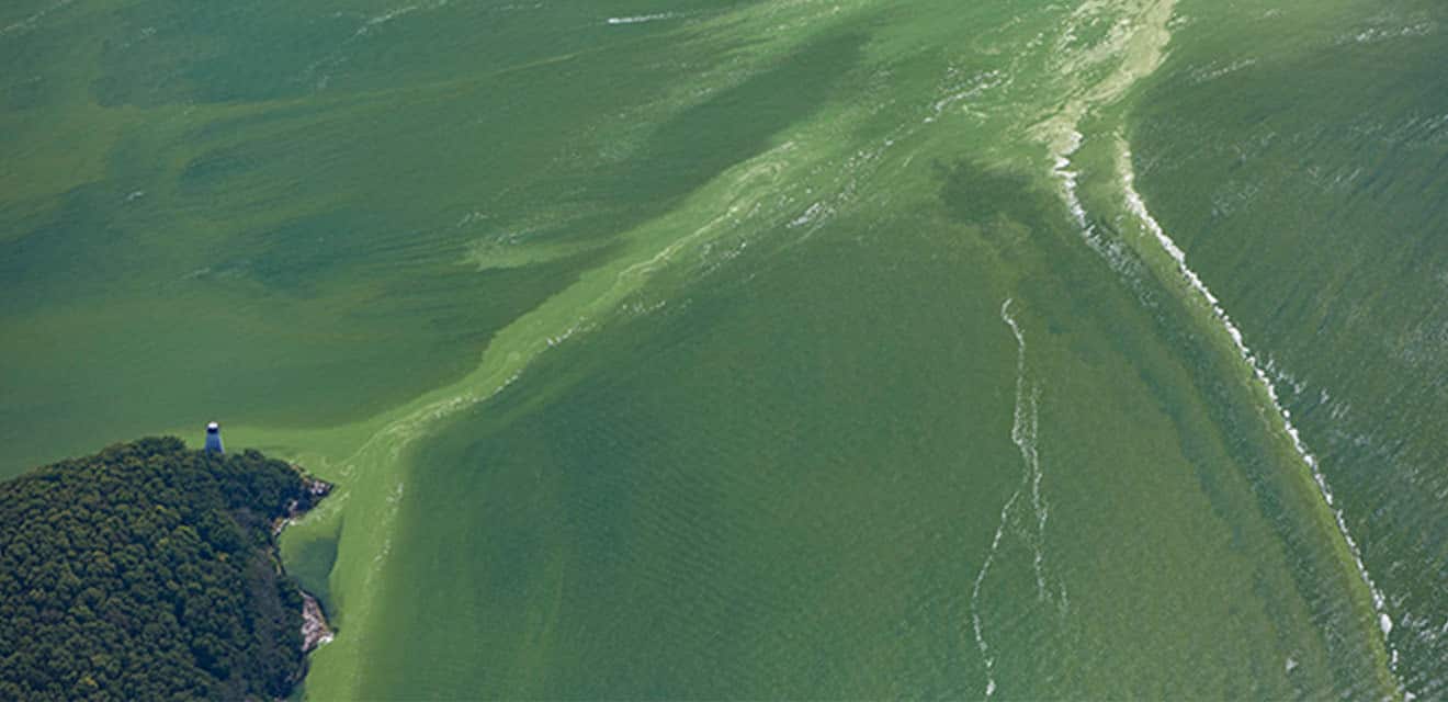
Most lakes that experience abundant algal blooms are eutrophic or hypereutrophic. Researchers determine the trophic status of a lake by measuring nutrient concentrations, mainly phosphate and total phosphorus, as well as algae (chlorophyll a) and water transparency, which are key factors in monitoring nutrients.
A hypereutrophic or eutrophic lake contains higher concentrations of nutrients, which cause persistent algae blooms and affect the balance of the aquatic ecosystem. Water fertility and the availability of elements such as potassium (K) and calcium (Ca) also influence this process.
One way to address eutrophication is to prevent nutrients from entering the water through rigorous nutrient monitoring and the use of field measurement tools, such as portable meters and specialized sensors. However, the solution to harmful blooms is rarely that simple. For years or even decades, excessive nutrient inputs have saturated many water bodies, allowing phosphate to accumulate in lake and reservoir sediments. This buildup hinders recovery and requires researchers to carefully interpret the monitoring data.
Stratification
Deeper lakes and reservoirs (generally more than 6 meters deep) often undergo stratification, a process in which the water is divided into different layers with varying temperatures and densities, which influences nutrient concentration and monitoring.
The epilimnion is the warmest water near the surface of a lake; the hypolimnion is the coldest and densest layer of water at the bottom; and the metalimnion is the intermediate layer, where the thermocline is located. The metalimnion changes from warm to cold between the epilimnion and hypolimnion layers, affecting the distribution of nutrients and other parameters such as pH and oxygen.
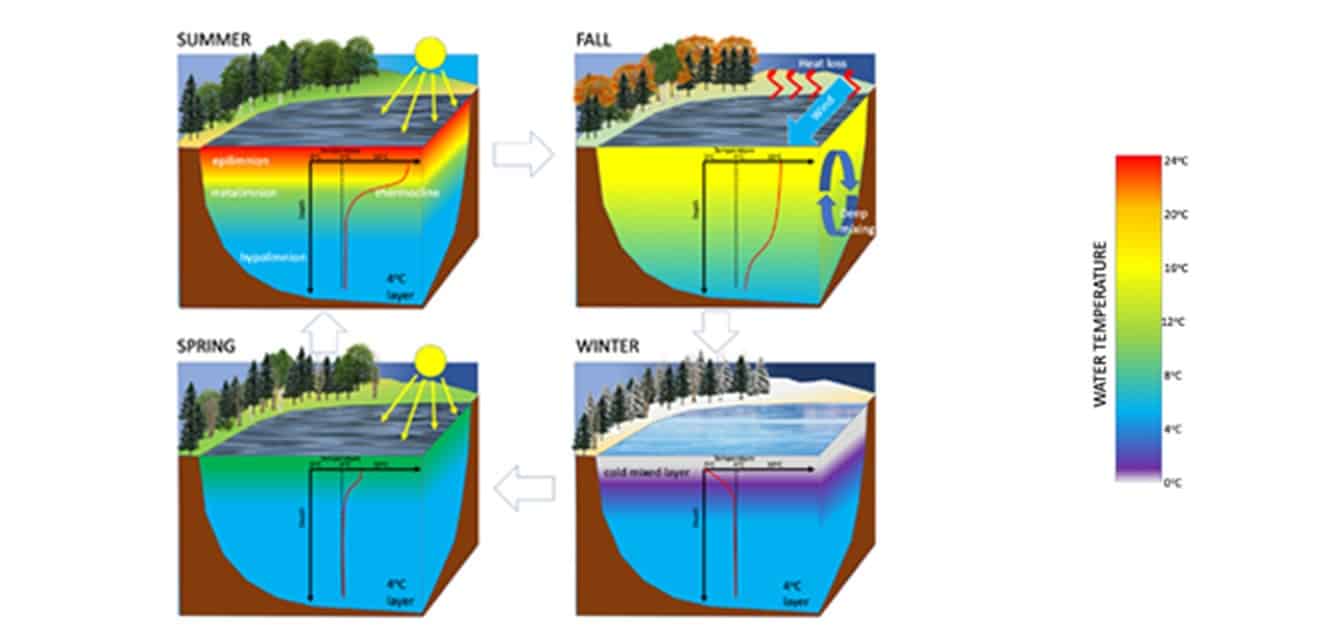
Phytoplankton and nutrients such as potassium (K) and nitrogen can accumulate near the interface of these thermal zones. The bottom of a mesotrophic or eutrophic lake usually remains anoxic (without oxygen) during stratification, affecting the concentration and availability of nutrients in the water solution. This causes an accelerated release of nutrients and other toxic substances (hydrogen sulfide, ammonia, etc.) from the sediments. Nutrient-rich sediments that accumulate over a long period of time, they feed algae blooms for years, even after external nutrient inputs decrease, disrupting the ecosystem’s performance and balance.
To know, you have to measure
Technological solutions for nutrient monitoring
We offer several solutions and equipment for nutrient monitoring that allow you to control and prevent algae blooms and their harmful effects, optimizing the nutrition and health of the aquatic ecosystem. To determine the best solution for a lake, we first accurately monitor and assess its condition using specialized meters and appropriate sampling.
The source of nutrients and the way a lake responds to nutrient enrichment are always complex and unique to each situation. Before using any treatment, the equipment must be properly calibrated and the lake’s chemistry must be evaluated through laboratory analysis and field measurements. We monitor the vertical, spatial, and temporal patterns of a series of water quality variables, obtaining reliable values for interpretation and application.
The MPC-Buoy uses ultrasound that directly impacts algae growth. This technology operates non-invasively, uses no chemicals, and targets only algae. It also improves light conditions for aquatic plants and beneficial bacteria in the sediment, helping naturally fertilise the ecosystem.
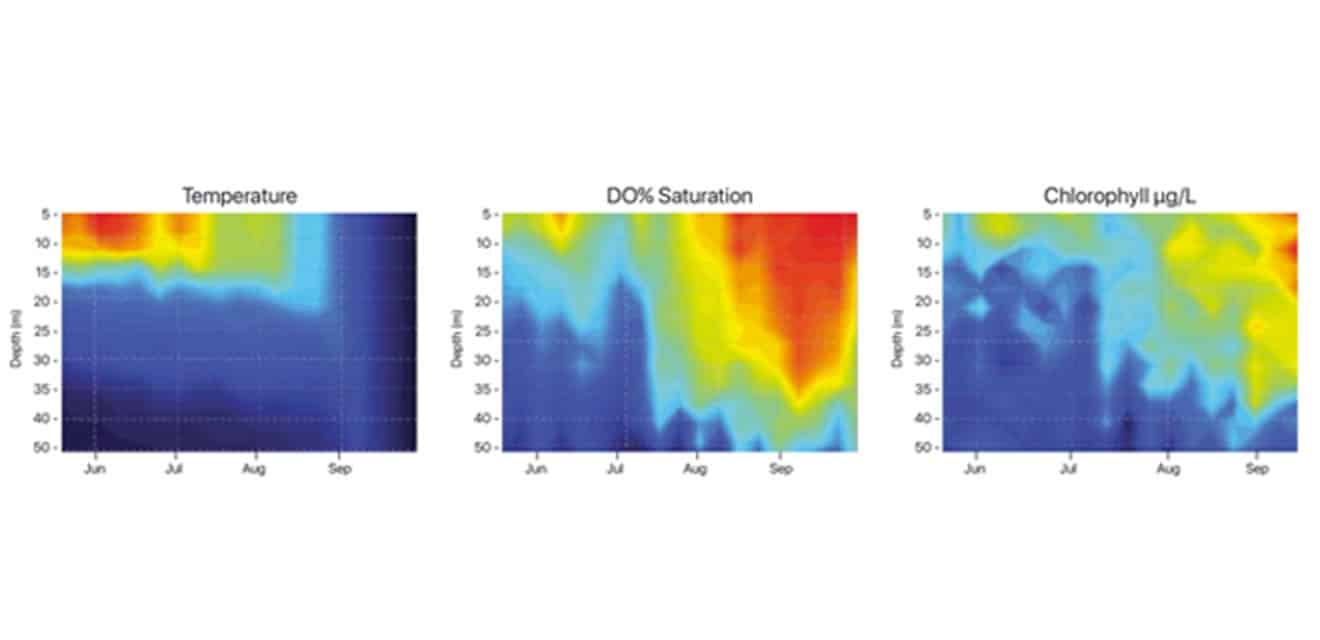
The Monitoring Buoy can profile the vertical column of a lake, autonomously measuring different variables, such as nitrate (N-NO3), phosphate (P-PO4), ammonium (NH4), turbidity, chlorophyll-a, phycocyanin, dissolved oxygen, temperature, pH, among others, within a wide range of applications for environmental control and management.
Real-time nutrient monitoring
Technicians can take nutrient monitoring measurements at different depths using a Vertical Profiling System. The system calculates data in real time and generates results several times a day enabling continuous analysis of nutrient concentration in the water.
Since these systems also provide a temporal overview, the data obtained from sensors and meters in the field can be used to identify the source and dynamics of nutrients within a body of water. The buoys detect the release of nutrients from the sediment and relate that information to the input of nutrients from other sources, providing a key reference for environmental management.
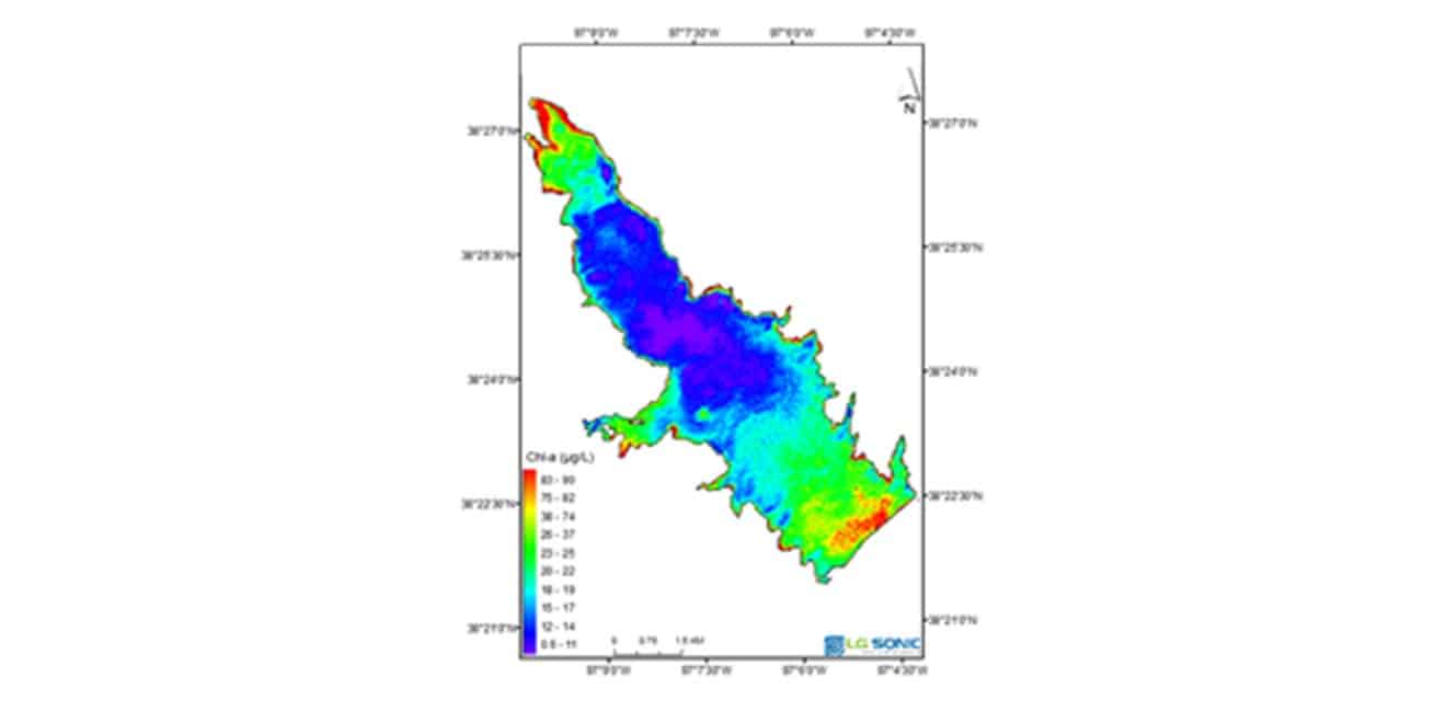
The role of satellite remote sensing
A lake or reservoir is rarely homogeneous. Its characteristics vary from meter to meter, or even from day to day. In addition, vertical stratification, variations in water quality, nutrient concentrations, and algae growth also vary horizontally. This is where satellite imagery provides a better understanding of the situation.
Remote sensing means using satellite data, such as Landsat or Sentinel images, to determine water quality parameters that can normally only be measured in a laboratory or using in situ sensors. However, the use of remote sensing has an unparalleled advantage, as it is the only data source that provides an overview of water quality parameters across the entire water surface. Large or inaccessible areas become accessible for monitoring.
Data integration and analysis with MPC-View
Scientists combine remote sensing with specific real-time data to interpolate information from buoys to other areas of a lake. By measuring variables such as chlorophyll a, turbidity, phycocyanin, and algal blooms, they can assess lake dynamics and determine its nutritional status. An additional bathymetric survey can determine where the highest point of sediment accumulation in a lake is located.
These data sources are processed in MPC-View, a web-based software, and provide insight into the relationship between nutrient input and sediment release. We can also determine the time of year when sediment releases critical nutrient loads, facilitating decision-making for irrigation and fertilization management.
Finally, by measuring nutrients in relation to other physical-chemical variables, we can determine the extent of nutrient availability throughout the water column, as well as the role of sediments in the nutrient cycle, supporting comprehensive and efficient nutrient monitoring.