Previous predictions about algae blooms in Lake Erie suggested that they would not be too severe, with a potential severity range of 2.5 to 4 on a scale of 1 to 10. However, a recent report has revealed that the situation is more serious than initially anticipated. This text analyzes the factors influencing algae blooms and their environmental impact on Lake Erie.
Location and geographical context of Lake Erie
Lake Erie, one of the five Great Lakes of North America, is part of the St. Lawrence River system, a major collector connecting lakes and rivers from Lake Superior to the Atlantic Ocean. It lies on the border between Canada and the United States, bordered to the north by the province of Ontario and to the south by the states of Ohio, Pennsylvania, Michigan, and New York. Its northern Canadian and southern US shores are regions of great environmental, economic, and social importance.
Among the lake’s best-known islands are Middle Island, Pelee, North Bass, South Bass, East Sister, Big Chicken, Little Chicken, Lost Ballast, and North Harbour. These areas are part of a valuable ecological environment where commercial fishing, tourism, and conservation are intertwined with local history and the culture of the lakeside communities.
Previous perspectives on algae blooms in Lake Erie
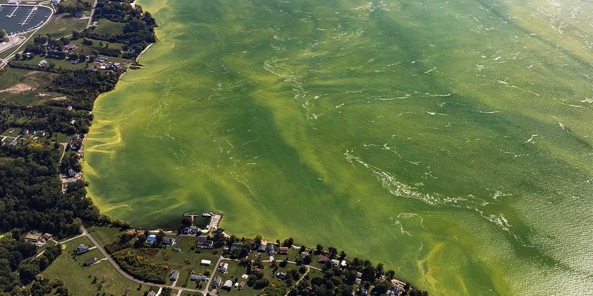
Lake Erie, located in the Great Lakes region, experiences harmful algal blooms (HABs) composed primarily of cyanobacteria, also known as blue-green algae. These blooms can produce a toxin called microcystin.
When they develop, cities and local governments must treat drinking water, close beaches, and manage impacts on public health and the regional economy, especially in the northern part of the lake and in tourist areas.
These algal blooms affect communities such as Toledo, Cleveland, Port Clinton, and other nearby cities. Many depend on Lake Erie not only for their water supply, but also for fishing and recreation.
The severity of blooms is measured on a scale of 1 to 10 by NOAA’s Ecological Forecasting initiative. This index is based on the amount of biomass during the 30 days of peak bloom. A score above 5 indicates a severe bloom; scores above 7 are especially severe, forming foam and covering large areas of the lake. The most severe blooms were recorded in 2011 and 2015, with scores of 10 and 10.5, respectively.
Last June, this year’s bloom was expected to reach a score of 3, with a range of 2 to 4.5. In comparison, last year’s bloom scored 6.8. It is important to note that size does not always reflect toxicity: a large bloom may have lower toxin concentrations than a small one. Each case is unique in size, toxicity, and impact on surrounding communities.
Severe bloom in Lake Erie region
A recent seasonal assessment, published on November 2 by the National Centers for Coastal Ocean Science, revealed that this year’s bloom scored 5.3 on the severity index, classifying it as moderately severe. Although lower than in 2022 (6.8), it is still higher than scientists had predicted.
Severity is determined by estimating biomass and surface area, as observed in satellite images. In 2023, the bloom covered 312 square miles, compared to 416 the previous year. It peaked in mid-August and was concentrated mainly along the US coastline from Monroe, Michigan, to Port Clinton, Ohio, a key area for commercial fishing and ecological conservation in Lake Erie. This area of Lake Erie is highly sensitive to temperature changes and nutrient accumulation.
This situation reinforces the importance of protecting the lake’s watershed and its tributary rivers, where phosphorus from the Maumee River is one of the main factors contributing to the proliferation.
Multiple factors at play in the Lake Erie ecosystem
Dr. Richard Stumpf, an oceanographer with the National Oceanic and Atmospheric Administration (NOAA), explained to the Sandusky Register that the increase in severity is the result of several factors. One of the most important is the early onset of blooms.
Starting earlier in the year allows algae to more effectively use the phosphorus present in the water, a nutrient that reaches the lake through rivers such as the Maumee, in the western part of Lake Erie. Smaller blooms tend not to take advantage of all the available phosphorus.
Another factor is the shift in the timing of peak blooms, which now tend to occur in August rather than around Labor Day, as was previously the case. This prolonged period, which Dr. Stumpf refers to as a “plateau” rather than a “peak,” contributes to their severity.
Dr. Stumpf is also exploring the possible connection between these conditions and climate change, analyzing whether late spring water temperatures influence the ecosystem. This system is part of the St. Lawrence River, which connects the Great Lakes to the ocean and acts as a natural nutrient sink between Canada and the United States.
He stated, “We are investigating the timing of spring blooms, including diatoms and other ‘good’ algae, to see if there have been any changes, as they compete with harmful algae.”
Ecological and economic importance of Lake Erie
Lake Erie is not only essential for commercial fishing and water supply, but also for the communities that inhabit its shores.
The local fishing fleet plays an important role in the regional economy, adapting to lake conditions and environmental regulations. Its river system is part of a vast natural environment that connects to the St. Lawrence River and the other Great Lakes, playing a key role in the ecological balance of the region.
Ecological and climatic context of Lake Erie
In addition to algal blooms, Lake Erie has remarkable biodiversity, with multiple species of fish, birds, and plants. Its variable surface area, length, and depth create diverse habitats, influenced by water temperatures and seasonality. In the northern part, islands such as Pelee, Middle Island, South Bass, North Bass, East Sister, and Lost Ballast are part of areas of high ecological value.
These regions, close to Ontario and the states of Ohio and Michigan, are recognized for their natural and tourist value. Fishing, both commercial and recreational, remains a central activity for coastal communities, while pollution reduction and phosphorus management are priorities for the lake’s future sustainability.
In summary, Lake Erie, shared by Canada and the United States, remains a vital ecosystem within the St. Lawrence River system. Despite phosphorus reduction efforts, algal blooms continue to pose a challenge to water quality, commercial fishing, and local communities. Its balance depends on joint efforts between the environmental authorities of both countries and the conservation of the natural areas surrounding the lake.